
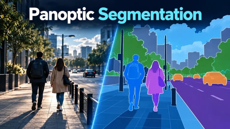
Panoptic segmentation turns an image into a scene map: which kind of region each pixel belongs to, and which separate object instance it represents. It combines semantic labeling with instance separation. A colored person region can describe where a system thinks a person is; it cannot tell you who that person is, whether a recording is authentic, or what happened outside the frame.
The useful skill is reading the map without giving it more authority than it deserves. This guide uses a deliberately simple, hypothetical street scene to explain the representation, compare its alternatives, and build a practical review worksheet. No model was run for the examples or illustrations.
What panoptic segmentation actually describes
A segmentation map divides visible image space into labeled regions. The original panoptic segmentation paper defines a joint class-and-instance representation: category information identifies the kind of region, while instance information separates countable objects. The output is a non-overlapping partition, with a provision for ambiguous or out-of-class pixels rather than a requirement to manufacture certainty everywhere.
Think of the difference between describing a photograph and annotating its visible surface. A description might say that pedestrians are walking near a road. An annotation asks where the road region begins and ends, which visible pixels belong to each pedestrian, and what the label vocabulary allows the annotator to call those regions. Neither operation automatically verifies the photograph’s origin.
That distinction matters when a polished overlay accompanies an online claim. A caption might announce that a system has “understood the whole scene,” but a reader still needs a narrower account of the operation. Was the map produced from this particular image? Does its legend distinguish separate instances? Was an uncertain area left unresolved? Those questions are answerable without accepting an unrelated claim about the event.
Start by keeping the source image and its overlay side by side. The source lets you inspect what was actually visible; the overlay shows one interpretation of those pixels. If only the overlay is available, request the source before discussing subtle boundary accuracy. A bright, neat patch can obscure rather than demonstrate the difficult part of the original.
Also write down the intended use. A classroom explanation, a dataset annotation review, and a video authenticity assessment need different evidence. For the last of those, our AI video detection methods guide explains broader evidence layers. A scene map should not become a substitute for that larger question simply because its colors look precise.
Semantic classes and object instances answer different questions
Semantic segmentation answers a category question. Instance segmentation separates individual countable objects. Panoptic segmentation brings those kinds of information into one scene representation. The research team’s explanation of Panoptic FPN describes a model architecture that addresses foreground instances and background classes together; it is an example of an implementation, not the definition of every possible system.
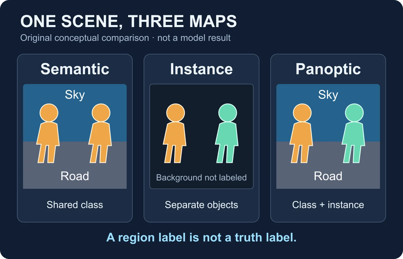
Here is a reading aid for the imaginary scene used throughout this article. The choices describe the task, not three measured outputs from commercial software.
| View | Useful question | What to avoid assuming |
|---|---|---|
| Semantic | Which visible areas are person, road or sky? | A shared person color does not mean there is only one person. |
| Instance | Which visible pixels belong to each separate pedestrian? | An object mask alone does not describe every background area. |
| Panoptic | How do separate pedestrians and background classes fit into one map? | Completeness of a map is not completeness of knowledge about the scene. |
Read the legend before reading the colors. A blue patch might mean sky in one illustration and a particular person in another. A color is a display choice, not a physical property of the subject. Treating a repeated color as proof that two regions share an identity is a mistake unless the legend explicitly defines that relationship.
For review notes, name the question you can answer in ordinary language. “The overlay separates the two visible pedestrians” is more informative than “the AI recognizes everything.” The narrower sentence tells another reviewer what you inspected and leaves room to disagree about a boundary without rejecting the entire representation.
Read one scene through three segmentation views
Imagine a wide image of a quiet street. A pedestrian stands on the left, another on the right, with visible space between them. Road occupies the lower region and sky the upper region. We deliberately omit signs, traffic, shadows with uncertain ownership, and other complications at first. This is an original teaching exercise, not a test photograph or a claim about model performance.
In the semantic view, ask a simple question: does the legend assign both pedestrians to the person class? If so, the same color can appear on two disconnected shapes. Circle those shapes separately in your notes even if the overlay does not distinguish them. You have learned about category coverage, but have not yet learned how the representation counts individual instances.
Next inspect the instance view. Give the two shapes temporary review names, such as left pedestrian and right pedestrian. Distinct display colors make their separation easy to see. Leave the road and sky out of your conclusion if that particular view does not label them. “Unlabeled in this view” is a better description than “the system failed to see the sky,” because the task might not have requested a sky label.
Finally inspect the panoptic view. Check that both pedestrian regions and the broad background regions appear in the same map. Look at the gap between the pedestrians: it should remain part of the appropriate background interpretation, not become an invisible bridge that joins the two people. Then compare the map with the original scene rather than judging the map by its visual tidiness.
Add a complication only after you understand the simple version. Suppose one pedestrian carries a bag that touches their coat. Ask what the supplied category definitions say about bags and carried objects. Do not decide the annotation is wrong merely because you personally prefer another grouping. First separate a disagreement about the rules from a disagreement about how those rules were applied.
A useful exercise ends with a limited conclusion: which representation answered your question, which detail remained ambiguous, and what additional context would help. It does not end with a score invented from the number of attractive colors on the screen.
A region label is not an object identity
An instance identifier is a local bookkeeping aid. When reviewing a map, treat a label such as person A as a reference to a region in the supplied representation, not a verified name, a persistent tracking identity, or proof that the person is the same across unrelated recordings. The distinction becomes especially important when someone presents an overlay as evidence about a particular individual.
For the street exercise, left pedestrian and right pedestrian are sufficient. These names identify what you are discussing without making a claim about who either person is. If another reviewer reverses the display colors, your notes can still be followed because they refer to the source scene and position rather than relying on color alone.
Imagine receiving two exported maps with different region numbers. Before claiming that one pedestrian changed identity, ask whether the files share a labeling convention at all. A new export could use different temporary IDs. Conversely, the same printed number in two files is not enough to establish continuity. Ask for the source frames, the method used to associate regions, and any documented limitations.
Do not turn a category into a claim about behavior either. A region labeled person does not establish that someone crossed a street, entered a building, or committed an act. Those are temporal and contextual claims. A single labeled frame might support a carefully worded observation about visibility, while the surrounding sequence supports or contradicts a different account.
This discipline also prevents misleading certainty about authenticity. A convincing category map can be drawn over a genuine scene, an edited scene, or an entirely generated illustration. The map’s labels alone do not settle which kind of media lies underneath. Keep representation, identity, action, and authenticity in separate sentences so that an uncertainty in one does not get silently promoted into certainty in another.
Boundaries, occlusion and categories create ambiguity
Begin with the places where you cannot confidently see a boundary. In the imaginary street scene, one pedestrian may stand behind a railing. Some body pixels are visible and others are hidden. Write “partially occluded” before drawing conclusions about missing detail. Filling in what you expect to exist behind the railing is a different operation from labeling what is visible.
Do the same with a blurred edge. Compare the overlay with the underlying image at a sensible viewing size, then inspect a closer view if the source supports it. A razor-sharp colored contour can make a soft photographic boundary look more definite than the evidence permits. Your note should describe the uncertainty in the source, not merely praise the overlay’s clean outline.
Category choices introduce another kind of ambiguity. An unfamiliar object may not fit the available labels; a familiar object may have a definition that differs from everyday language. The original task permits a void designation for ambiguous or out-of-class pixels. Ask how the particular export represents that state rather than assuming that every blank area means the same thing.
Now return to the carried bag. Consider three separate questions: is the bag visibly distinguishable, does the label vocabulary contain a suitable category, and does the annotation rule require it to be separate from the carrier? A disagreement about the first question concerns image evidence. A disagreement about the other two concerns the representation’s rules. Keeping them apart makes a review much more productive.
There is also a difference between a locally questionable boundary and a globally unsuitable interpretation. A small uncertain sleeve edge need not invalidate every region in the map. But if a whole background surface is assigned an implausible class, it may affect the specific application for which the map was supplied. Explain the consequence rather than treating all errors as interchangeable.
A restrained uncertainty vocabulary helps: boundary unclear, class unsupported by the visible source, instance separation unresolved, region outside the supplied vocabulary, or source unavailable for comparison. These are review descriptions, not conclusions that media was manipulated. If a source or definition is missing, leave the decision open and record exactly what you need next.
Use a scene-label worksheet without inventing missing evidence
A worksheet is useful when it makes observations reproducible. It is not useful when it turns guesses into checkmarks. The following is an original template for the hypothetical street scene. Copy the questions, replace the teaching observations with your own, and retain an explicit unresolved column instead of forcing a pass or fail for every region.
| Review item | Observation to record | Unresolved question |
|---|---|---|
| Source and overlay | Both refer to the same visible street composition. | Was the source cropped or resized before labeling? |
| Category legend | Person, road and sky meanings are supplied. | How are uncertain pixels represented? |
| Separate instances | Left and right pedestrian regions are distinguished. | Is the gap between them assigned consistently? |
| Occlusion | The railing hides part of one pedestrian. | Does the display imply an unsupported hidden contour? |
| Export context | Map and legend are retained together. | Are region IDs local to this image or associated across frames? |
Complete the source row first. If someone supplies only a screenshot of an overlay, say so. If the original is a different crop, do not compare edge positions as though both images have the same coordinate system. Ask for a matched pair, and preserve the received files before creating any resized copy for discussion.
Complete the legend row next. List the labels you actually received, not every label you imagine the model could support. Request a short explanation of any reserved value, unassigned area, or special group treatment. An unlabeled patch can be important precisely because its meaning is unclear. Inventing a confident name for it removes information rather than adding it.
For each disputed region, write an observation and a next action together. “The right pedestrian’s sleeve merges visually with the railing; request a source crop at its available resolution” gives the next reviewer something concrete to do. “Bad AI” does not describe the problem and may conceal a perfectly ordinary visibility limitation.
Export details deserve their own note. The original COCO panoptic API documentation describes a single image representation holding non-overlapping segments and separate tooling for evaluation, conversion, and visualization. That distinction is useful: a rendered color preview is not necessarily the full annotation record. If the only material you have is a preview, do not assume that every rule or identifier can be recovered from its appearance.
Keep this worksheet as a reading aid, not a homemade benchmark. A genuine evaluation needs the relevant reference annotations and an appropriate metric. The original paper’s panoptic quality framework compares predicted regions with reference regions; it is not a probability that a video is real. Without a defined evaluation setup, report observations in words instead of inventing a numerical accuracy score.
Keep video continuity and provenance separate from a pixel map
A video offers more context than a single frame, but it also creates more opportunities to overinterpret a label. Imagine that the left pedestrian moves behind the other one in the next moment. A reviewer should first watch the source sequence at normal speed, then examine the relevant adjacent frames. Comparing two isolated, differently colored overlays may hide the very movement that explains their differences.
Ask whether the supplied system is labeling each frame independently or performing a documented temporal association. Do not assume continuity from a product screenshot. If the provider cannot explain that distinction, describe the maps as frame-level interpretations and leave cross-frame identity unresolved. This avoids turning a convenient display into an unsupported tracking claim.
Also ask how the review copies were produced. Cropping, scaling, compression, and annotations can affect what a later viewer sees. Keep notes about your own transformations and distinguish the source from explanatory copies. An overlay prepared for an article should be clearly identified as an illustration, as the diagram here is.
Provenance belongs in a separate record. A scene label is inferred from visible content; provenance concerns information about origin and creation history. Our Content Credentials guide explains that separate layer and its limitations. Do not treat either a present label map or a missing provenance record as a stand-alone authenticity verdict.
When the actual question concerns possible video generation or manipulation, retain the original clip and state the claim being assessed. The AI video analysis guide provides the broader context for combining available signals. This article does not claim that DetectVideo AI exposes panoptic masks, region IDs, or a person-identification service. A useful scene representation and a useful integrity analysis remain different outputs.
A practical review checklist before trusting an overlay
Finish a review by asking whether another person could understand your conclusion without sharing your assumptions. Show them the source, the legend, the relevant region, and the limitation. An annotation can support a helpful observation even when it cannot support the bigger claim attached to a social post or presentation.
- Name the task. Establish whether the map describes categories, separates instances, or combines both. Do not evaluate a background omission as an error in a view that intentionally covers only objects.
- Match the source. Check the crop and orientation before comparing boundaries. Preserve an unannotated copy so that the overlay cannot become the only evidence left.
- Read the legend. Record category definitions, temporary instance labels, and uncertainty conventions. Do not infer identity or confidence from color alone.
- Inspect difficult regions. Look at overlaps, occlusions, unclear edges, and unfamiliar objects. Write what is visible separately from what you expect behind it.
- Separate image and video claims. Request the relevant sequence for a movement or continuity claim. A frame annotation does not document an entire action.
- Report the boundary of the conclusion. State which observation the map supports, what remains uncertain, and which source or rule would help resolve it.
For our street exercise, a reasonable closing note might read: “The conceptual panoptic view separates two pedestrian instances while labeling broad road and sky areas. The bag grouping depends on the supplied rules, and the railing limits what can be seen. No identity, event, or authenticity conclusion follows from the map.” This is a model of cautious reporting, not a result from software.
The practical value of panoptic segmentation is a richer scene representation. The practical value of a careful reviewer is knowing when that representation answers the question and when it does not. Keep the useful information, preserve the unresolved details, and resist the temptation to turn a complete-looking overlay into complete knowledge.
Questions about panoptic segmentation
What is the difference between semantic and panoptic segmentation?
Semantic segmentation assigns categories to image regions. Panoptic segmentation also distinguishes separate instances of countable objects within a unified scene map. Two visible people can share a semantic class while remaining separate panoptic instances.
Does an instance label identify a particular person?
No. A region identifier is not a verified human identity. Do not use it as a name or assume that it persists across frames unless the particular temporal association method is documented.
Does a panoptic map describe hidden parts of objects?
The original task concerns visible image regions. Reconstructing an object’s hidden extent is a different question. If an illustration fills in a hidden area, it should make that assumption explicit rather than present it as observed evidence.
Can a good segmentation map prove that a video is real?
No. A map can be produced from genuine, edited, or synthetic imagery. Its region labels do not verify capture history, event context, or the absence of manipulation. Those questions require separate evidence.
Why do some pixels have no ordinary class label?
They may be ambiguous or outside the available category vocabulary. Check the export’s uncertainty or void convention. A blank display area is not automatically a missed object, and guessing its class can make a review less accurate.
A scene label is not a truth label.
For a related video, combine technical analysis with the source and context instead of trusting an overlay alone.
Sources and reading scope
- Kirillov and colleagues: Panoptic Segmentation — original task format, visible-region scope, ambiguity treatment, and evaluation definition. Historical research, not a current product benchmark.
- COCO panoptic API — original format, converter, evaluation, and visualization documentation. No installation or model run was performed.
- Engineering at Meta: Improving scene understanding through panoptic segmentation — first-party Panoptic FPN research explanation. Its dated performance comparisons are not reproduced here.
Sources accessed on 14 October 2026. All street-scene examples, worksheets, and illustrations are original conceptual teaching material, not captured evidence or measured experimental results.